
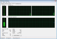
Integrated Graphical User Interface
Fully integrated interface combining easy to use graphical tools (e.g., sources, buildings, and receptors), seamless model run, and automated contouring and posting of results.
Overview
AERMOD View is a complete and powerful air dispersion modeling package which seamlessly incorporates the following popular U.S. EPA air dispersion models into one integrated interface:
These US EPA air dispersion models are used extensively to assess pollution concentration and deposition from a wide variety of sources.
The AMS/EPA Regulatory Model (AERMOD) is the next generation air dispersion model based on planetary boundary layer theory. AERMOD utilizes a similar input and output structure to ISCST3 and shares many of the same features, as well as offering additional features. AERMOD fully incorporates the PRIME building downwash algorithms, advanced depositional parameters, local terrain effects, and advanced meteorological turbulence calculations.
We have an extensive list of standard features included with AERMOD View, a list that no other software package comes close to having or only as add-ons that cost you more.
For example, AERMOD Parallel, for up to 8 processors, is included in the package at no extra cost!
Essential client options such as complete AERMET and PCRAMMET meteorological data preprocessing and multiple pollutant utilities for modeling multiple pollutants in a single AERMOD, ISCST3 or ISC-PRIME run come standard. Many more features are also always included at No additional cost.
Features
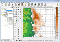
Fully integrated interface combining easy to use graphical tools (e.g., sources, buildings, and receptors), seamless model run, and automated contouring and posting of results.
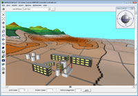
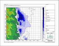
Complete 3D visualization of your entire modeling area. Sources, buildings, and concentration and/or deposition contour results are displayed in context with the surrounding terrain.

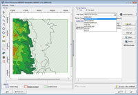
This exciting feature allows you to export your buildings, sources, receptors and contours into Google Earth giving you a more realistic image of where your pollutants will impact surrounding areas.
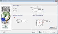
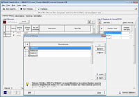
The New Project Wizard allows you to quickly and easily set up a new project in AERMOD View. You can setup your project by specifying a reference point in Latitude/Longitude, UTM, or any other local coordinate system.
Included in the package, at no extra cost, is AERMOD MPI, Lakes Environmental parallel version of AERMOD. This will significantly cut down on model run times, while still giving the high quality results you expect from AERMOD View.
Take advantage of the ready-to-use printout template. You can include your company logo, project number, and other project specific information.
This utility will boost your productivity drastically by allowing you to specify emissions from several pollutants emitted by the same source. No need to setup different projects for each pollutant!
Advanced terrain processing capabilities are offered for several terrain data file formats such as NED, SRTM, and USGS DEM. Automated download of terrain data files from webGIS. SRTM3 Terrain data at 90 m resolution available worldwide.
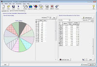
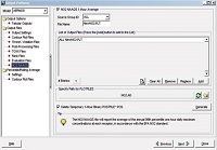
Several tools are available for easy processing of meteorological data for AERMOD and ISC models.The AERSURFACE utility allows you to automatically calculate the required surface characteristics.
The U.S. EPA hourly National Ambient Air Quality Standard for NO2 is not calculated directly by the AERMOD model, however, AERMOD View includes an easy-to-use tool which will quickly calculate these values.
Technical Specifications
AERMOD View is an interface for the AERMOD, ISCST3, and ISC-PRIME US EPA air dispersion models. See below technical specifications for these 3 models:
AERMOD| Parameter | Description | |
|---|---|---|
| Model Name | AERMOD | |
| Developed By | AERMIC - (American Meteorological Society (AMS) and United States Environmental Protection Agency (US EPA) | |
| Model Type | Steady-state Gaussian plume air dispersion model | |
| Range | Up to 50km from the source | |
| Atmospheric Stability Model | Planetary boundary layer theory, turbulence scaling concepts | |
| Wind Field | Homogeneous | |
| Release Types | Buoyant or neutrally buoyant plumes | |
| Emission Types | Constant or time-varying, planned or fugitive | |
| Atmospheric Chemistry | NOX to NO2 and SO2 decay | |
| Source Types | Point, area, volume, open pit, line*, flare* | |
| Meteorology | Hourly surface and upper air data (processed by AERMET) | |
| Terrain | Flat or elevated (terrain processed by AERMAP) | |
| Receptors | Several types of grids (Cartesian, polar) and discrete receptors | |
| Other Options | Building downwash (modeled by BPIP-PRIME) | |
| Regulatory Status | Preferred US EPA regulatory model for near-field applications | |
* Pseudo source types
ISCST3| Parameter | Description | |
|---|---|---|
| Model Name | ISCST3 - Industrial Source Complex Short Term model (US EPA) | |
| Developed By | United States Environmental Protection Agency (US EPA) | |
| Model Type | Steady-state Gaussian plume air dispersion model | |
| Time Step | 1 hour | |
| Range | Up to 50km from the source | |
| Atmospheric Stability Model | Pasquill-Gifford Stability Classes | |
| Wind Field | Homogeneous | |
| Release Types | Buoyant or neutrally buoyant plumes | |
| Emission Types | Constant or time-varying, planned or fugitive | |
| Atmospheric Chemistry | NOX to NO2 and SO2 decay | |
| Source Types | Point, area, volume, open pit, line*, flare* | |
| Meteorology | Hourly surface data and mixing height data (through PCRAMMET) | |
| Terrain | Flat or elevated | |
| Receptors | Several types of grids (Cartesian, polar) and discrete receptors | |
| Building Downwash | Modeled by BPIP | |
| Regulatory Status | Former US EPA regulatory model for near-field applications | |
* Pseudo source types
ISC-PRIME| Parameter | Description | |
|---|---|---|
| Model Name | ISC-PRIME model | |
| Developed By | United States Environmental Protection Agency (US EPA) | |
| Model Type | Steady-state Gaussian plume air dispersion model | |
| Time Step | 1 hour | |
| Range | Up to 50km from the source | |
| Atmospheric Stability Model | Pasquill-Gifford Stability Classes | |
| Wind Field | Homogeneous | |
| Release Types | Buoyant or neutrally buoyant plumes | |
| Emission Types | Constant or time-varying, planned or fugitive | |
| Atmospheric Chemistry | NOX to NO2 and SO2 decay | |
| Source Types | Point, area, volume, open pit, line*, flare* | |
| Meteorology | Hourly surface data and mixing height data (through RAMMET) | |
| Terrain | Flat and elevated | |
| Building Downwash | Modeled by BPIP-PRIME | |
| Regulatory Status | Former US EPA regulatory model for near-field applications | |
* Pseudo source types
System Requirments
This product is a Microsoft Windows-based program that can be installed in the following Windows operating systems:
Minimum requirements: