
CALPUFF View provides a complete graphical solution for the CALPUFF modeling system: CALPUFF, CALMET, CALPOST, and their related pre- and post-processors. All three modeling systems are supported by the interface:
- USEPA Approved Version 5.8
- Version 6
- Version 7
CALPUFF View includes powerful and independent QA tools, stunning report-ready results, and a wide range of visualization options.
CALPUFF is a sophisticated model and is used in many modeling scenarios including:
| Toxic pollutant deposition | Visibility assessments |
| Complex terrain | Secondary pollutant formation |
| Long range and overwater transport | Building downwash |
| Costal interaction effects | Dry deposition |
| Fumigation conditions | Chemical transformation |
| Sub-hourly time steps |
ABOUT CALPUFF
CALPUFF is a multi-layer, multi-species non-steady-state puff dispersion model which simulates the effects of time-and space-varying meteorological conditions on pollution transport, transformation, and removal. The CALPUFF modeling system includes:
- CALMET – Diagnostic three-dimensional meteorological model
- CALPUFF – The puff dispersion model
- CALPOST – Post-processor for calculating time-averaged concentrations, deposition fluxes, and visibility impacts
WHY CALPUFF
- CALPUFF can be applied to a wide variety of scenarios including far-field impacts (those beyond 50km from releases) which cannot be modeled with traditional plume models (e.g., AERMOD).
- Its three-dimensionally varying meteorological field makes it useful for regions with very complex terrain or non-steady-state conditions.
- CALPUFF View’s wide range of features make it easy to execute the entire suite of pre- and post-processors for a modeling analysis
Features
Key Features
PARALLEL CALMET
Increase your processing capability! CALPUFF View can utilize multiple cores when running the CALMET model to generate model data faster than ever before.
Lakes Tile Maps
Fully integrated GIS-based interface combining easy-to-use graphical tools for drawing sources, buildings, and receptors; seamless model run execution; and automated contouring and posting of results.
Plume Animation
This exciting feature allows you to play and record plume animations along with your wind field.
Export to Google Earth
This exciting feature allows you to export your buildings, sources, receptors, and contours into Google Earth giving you a more realistic image of where your pollutants will impact surrounding areas.
Puff Tracking Animations in Google Earth
Using the export to Google Earth feature, you can quickly and easily see where your puff will impact. The play feature shows how your puff disperses over time.
Auto-Download of Terrain/Land Use Data
CALPUFF View allows the user to automatically download high-resolution global terrain data files (DEM, CDED, NED, SRTM, GTOPO) and land use data files (USGS CTG, NLCD92, EOSD, CORINE, GLCC). Easily and quickly process data for anywhere in the world.
Complete MET Pre processors
CALPUFF View seamlessly runs SMERGE, METSCAN, READ62, PXTRACT, and PMERGE for all of your met processing. Surface, Upper Air, and Precipitation files can be downloaded automatically from WebMET.
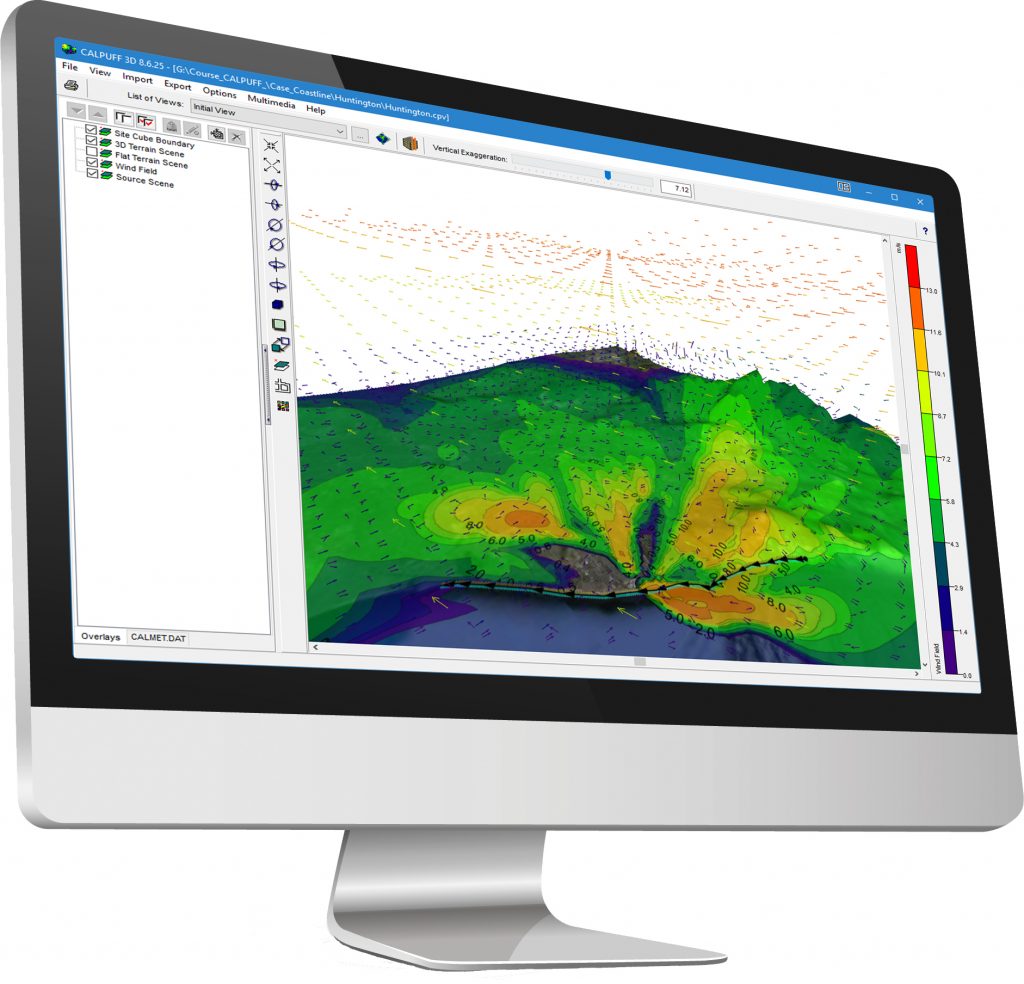
Powerful 3D Visualization
Complete 3D visualization of your entire modeling area. Sources, buildings, wind field, and concentration/deposition contour results are displayed in context with the surrounding terrain.
CALPUFF View Easy-to-Use Wizards
CALPUFF View provides an easy-to-use graphical interface. Each section can be completed by following the steps outlined in various wizards so that you don’t miss specifying required information.
Integrated GUI
Fully integrated GIS-based interface combining easy to use graphical tools for drawing model objects; seamless model run execution; and automated contouring and posting of results.
Sloped Roof Tool
This utility allows users to automatically create multiple building tiers based on the defined top and bottom tier to create the appearance of a sloped roof.
Professional Printing Templates
Take advantage of the ready-to-use printout template. You can include your company logo, project number, and other project specific information.
Specifications
Technical Specifications
This product is a Microsoft Windows-based program that can be installed in the following Windows operating systems:
- 32-bit and 64-bit Operating Systems
- Windows 10
Minimum Requirements:
- An Intel Pentium 4 processor (or equivalent) or higher
- At least 2 GB of available hard disk space
- 1 GB of RAM (2 GB recommended)
Contact Us